Salt Production In Stafford.

Gramaisc

Forum O. G.
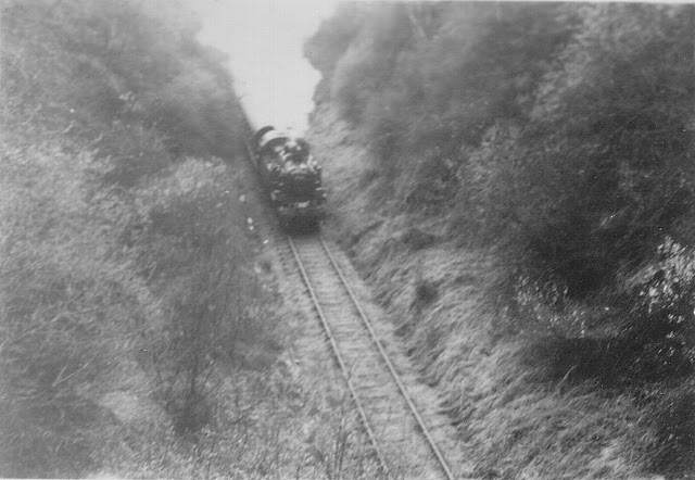
WOW Salt has expanded a bit !!! We used to play in the derelict Salt Railway Station as kids after walking up through deep railway cuttings parallel to the Sandon Road, just past the Hopton turn off (where there was a railway bridge, now long gone.) You can still see the outlines of the cuttings on Google Earth.
And deep the cutting certainly was.

hopton-cutting-tif.jpg
 

Thehooperman

Well-Known Forumite
When I was at school I was allowed to ride in the cab of the station shunter up to the RAF camp and back (perks of my Dad being station supervisor).

I think it was an inspection run as I don't recall any shunting moves at the camp.

As a result of this adventure I did some research about the line as part of a school project.

If I remember correctly the line closed well before Beeching c1951 except to the RAF camp and common salt works sidings. There was a special train run in 1957 by a railway club and the tracks were lifted apart from to the RAF camp shortly after that.

Loxley tunnel was also known Bromshall (not Bramshall as you might expect) tunnel.

This thread prompted me to search for some photos of the salt works and I found this one.
Screenshot_20221006-183735.png


There's also a then and now video and it shows this in the Stafford common section (not sure if it is though).
Screenshot_20221006-183511.png
 

Glam

Mad Cat Woman
So, at the risk of sounding like a dumb blonde, which I'm far from.
How far under Stafford did the salt mining go? What is built above there now?
 

The Hawk

Well-Known Forumite
The very last passenger service, making its very last station stop (at Grindley) on the Stafford & Uttoxeter railway in 1957, as it returned to Stafford.
Taken from the book 'The Stafford & Uttoxeter Railway' by Allan C. Baker & Mike G. Fell
There is a current resident of Jerningham Street who was on that train.
1665082501320.jpeg
 

Gramaisc

Forum O. G.
So, at the risk of sounding like a dumb blonde, which I'm far from.
How far under Stafford did the salt mining go? What is built above there now?

It was hydraulic mining. You bored a hole, pumped water down it and it came up another hole as brine. You had little control over where the dissolved salt actually came from and no mean of shoring up any cavities created as it was washed away. Thus, subsidence occurred randomly, one of the worst affected areas was around the south end of Oxford Gardens, Corporation Street, Sandyford Street (particularly) and Crooked Bridge Road.

There were other salts works locally, not just at the Common - Baswich was fed from the Common, but there were works at Weston and Shirleywich, too - subsidence was less of an issue in rural areas.


Anyway, I don't think you're blonde.
 

Thehooperman

Well-Known Forumite
The very last passenger service, making its very last station stop (at Grindley) on the Stafford & Uttoxeter railway in 1957, as it returned to Stafford.
Taken from the book 'The Stafford & Uttoxeter Railway' by Allan C. Baker & Mike G. Fell
There is a current resident of Jerningham Street who was on that train.
View attachment 13030
Ah, that was the special train run by a railway club that I mentioned.

The last timetabled service was some years before that.
 

The Hawk

Well-Known Forumite
So, at the risk of sounding like a dumb blonde, which I'm far from.
How far under Stafford did the salt mining go? What is built above there now?
It was hydraulic mining. You bored a hole, pumped water down it and it came up another hole as brine. You had little control over where the dissolved salt actually came from and no mean of shoring up any cavities created as it was washed away. Thus, subsidence occurred randomly, one of the worst affected areas was around the south end of Oxford Gardens, Corporation Street, Sandyford Street (particularly) and Crooked Bridge Road.

There were other salts works locally, not just at the Common - Baswich was fed from the Common, but there were works at Weston and Shirleywich, too - subsidence was less of an issue in rural areas.


Anyway, I don't think you're blonde.
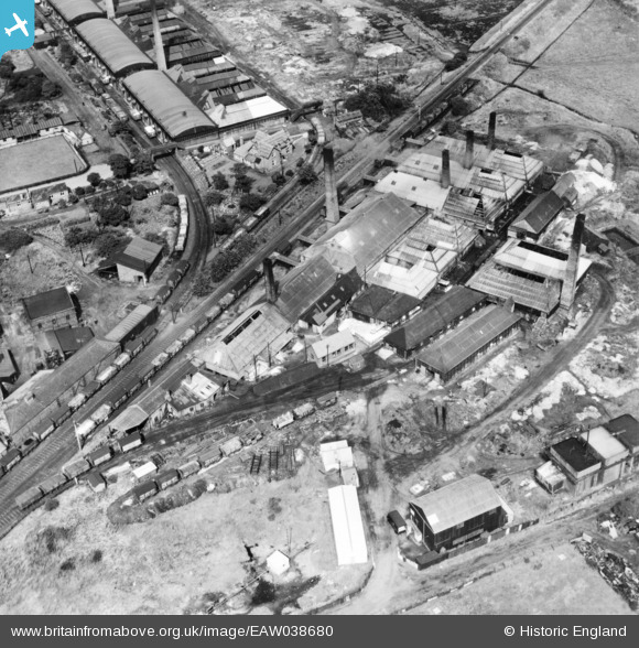
The three main salt works were located on both sides of the line just east of Stafford Common station. The two on the northern side of the line occupied an area including and around the site of Stafford Recycling Centre, whilst the other one (south of the line) occupied roughly around where Stafford Mobile Tyre & Battery Services Ltd is based, at the top end of Drummond Road. All three had railway sidings off the Stafford & Uttoxeter Railway.
 

Gramaisc

Forum O. G.
On the subsidence front, the technology has changed now, but you could at one time see small glass plates, like microscope slides, glued across a crack in brickwork, to determine if it was still moving. I believe that @tek-monkey lived in a house with some on in Sandon Road, but it might have been nextdoor.


The extent of the works.

EAW038680.jpg


It's this sort of area, here.


Glam

Mad Cat Woman
The three main salt works were located on both sides of the line just east of Stafford Common station. The two on the northern side of the line occupied an area including and around the site of Stafford Recycling Centre, whilst the other one (south of the line) occupied roughly around where Stafford Mobile Tyre & Battery Services Ltd is based, at the top end of Drummond Road. All three had railway sidings off the Stafford & Uttoxeter Railway.
I know you can say, how long's a piece of string?
But what are the chances of those places just collapsing into a hole one day? Or was the underneath of them filled in before building work was undertaken? I know I sound daft, but I'm also nosey and like to find out things about places.
 

The Hawk

Well-Known Forumite
I know you can say, how long's a piece of string?
But what are the chances of those places just collapsing into a hole one day? Or was the underneath of them filled in before building work was undertaken? I know I sound daft, but I'm also nosey and like to find out things about places.
I believe that the salt extraction extended under a sizeable part of Stafford, beyond the footprints of the works themselves. I believe over 50 years on there is still the potential for some ground movement as a consequence of the salt works, although I suspect it won't cause Stafford to disappear into some giant hole (cue someone responding that Stafford is a giant hole).
 

Gramaisc

Forum O. G.
I know you can say, how long's a piece of string?
But what are the chances of those places just collapsing into a hole one day? Or was the underneath of them filled in before building work was undertaken? I know I sound daft, but I'm also nosey and like to find out things about places.
The subsidence largely stopped around 1970, fairly quickly after the pumping ceased, so it's unlikely that there'll be any more on any scale - but, the initial brine sources were natural wells, so there could be a slow removal of the salt by groundwater movements. Apart from the evidence of the subsidence at the surface, there's little definitive information on where the salt was removed from - you just pump the water down, let it go off where it likes, then collect it as it comes back up.

Never say never, but probably not.

The classic example of the remote subsidence is Sandyford Street, which doesn't really have any pre-1970 structure left on it. There were some houses left up to around 1980 - a friend lived in one in the mid-70s. If you took the draught reduction newspaper out of the cracks in the front wall, you could actually touch hands with someone outside on the footpath.


and steep sided with plenty of vegetation.

That is the final trip, which took place after a long period of disuse.
 

Glam

Mad Cat Woman
Is this why Crooked Bridge road is so called? Or is that just as a result of the brook down there?
 

Gramaisc

Forum O. G.
Is this why Crooked Bridge road is so called? Or is that just as a result of the brook down there?
It seems plausible that the bridge over Sandyford Brook was somewhat affected, the Prison wall there was - the towers on the corner at Gaol Road were demolished as 'unsafe', in the 50s, I think.

The original prison wall adjacent to the St George's land had some large cracks in it in the 70s.

This is the current bridge.

DSC_0883.JPG
 
Top