-
Welcome to Stafford Forum. Please or sign-up and start posting!
You are using an out of date browser. It may not display this or other websites correctly.
You should upgrade or use an alternative browser.
You should upgrade or use an alternative browser.
Nostalgia - What are your memories of Stafford?
- Thread starter MISS T
- Start date
Mudgie
Well-Known Forumite
Thanks for that.I heard that it was at the bottom of Sunningdale Drive and Colwich Crescent, where the small green "playing area" is, just dont have a ball with you or made lady on the corner would come out and shout at you, threatening to call the fuzz.....she never did
I still remember the golf house being there before it was knocked down for Kingston Hill Court to be built. Morris drive on wards was still a HUGE building site. lots of fun knocking about in the foundations / builds wrecking havoc
Mudgie
Well-Known Forumite
A fascinating photograph.1935.
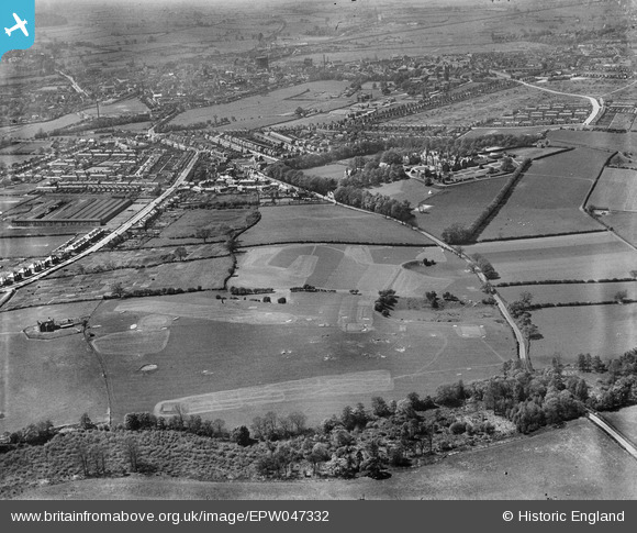
No houses, and not many trees in Kingston Pool Covert.
Mudgie
Well-Known Forumite
I never knew there was a hospital there.1880.
Shows a few escarpments and describes the building on the hill as Kingstonhill Hospital (infectious diseases).
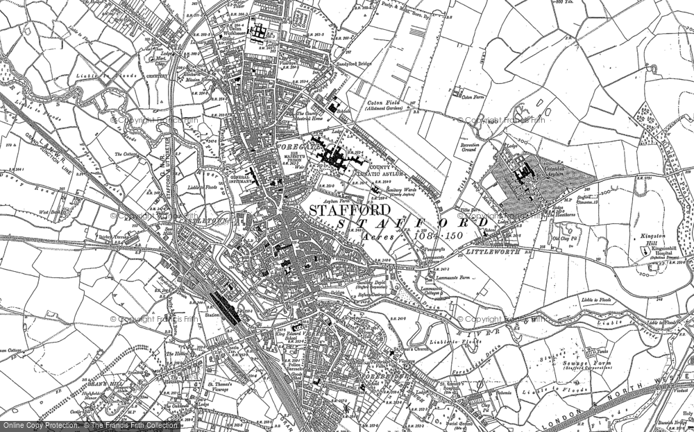
And I'm surprised at houses on Corporation Street which I thought was about Edwardian.
Gramaisc
Forum O. G.
It seems that the land belonged to the Earl of Shrewsbury and that may be part of why the club migrated to Ingestre, although now threatened by HS2...A fascinating photograph.
No houses, and not many trees in Kingston Pool Covert.
Gramaisc
Forum O. G.
Past Track says Corporation Street was mostly built in the 1890s. It's not beyond the bounds of possibility that some information could have been included on a map from a slightly earlier date, based on planning information - for example, there is a map showing the route of the Stafford-Uttoxeter railway following a slightly different route from that which actually existed in reality.I never knew there was a hospital there.
And I'm surprised at houses on Corporation Street which I thought was about Edwardian.
However - I'm not convinced by the date that was given for that map - it describes the Prison as being His Majesty's...
Oxford Gardens houses don't seem to be there - I suspect it may be more like 1905ish...
OK, there is no sign of the 'new' Lotus factory, so around 1903 - probably - to be in time with a male monarch...
Last edited:
Gramaisc
Forum O. G.
This would imply that your information may be correct.I heard that it was at the bottom of Sunningdale Drive and Colwich Crescent, where the small green "playing area" is,

That would line up with where the odd open space is in Colwich Crescent.
Presumably filled in, but not built on?
Mudgie
Well-Known Forumite
That's fascinating.This would imply that your information may be correct.
That would line up with where the odd open space is in Colwich Crescent.
Presumably filled in, but not built on?
Old Clay Pits, Old Marl Pits and an Old Quarry.
And there's 'Allotment Gardens' where or near where there are now.
Mudgie
Well-Known Forumite
There's a bit of bare sandstone on the grassed area with the big poplar near Colwich Crescent - and it's only a foot underground at the top left corner of our garden.the level of sand stone on the south side of kingston hill is quite substantial.
where the old quarry is situated does look to be the junction of Colwich crescent and Wolsley Road

There's sandstone visible in many places other nearby, on Beacon Hill, near Hopton Pools, by the Upper Hanyards, etc.
Noah
Well-Known Forumite
Quite a few pits on this Victorian/Edwardian 25" map. Move the trancparency slider to see what is there now
https://maps.nls.uk/geo/explore/#zoom=16&lat=52.80896&lon=-2.09640&layers=168&b=1
Play with some of the other maps available as well.
https://maps.nls.uk/geo/explore/#zoom=16&lat=52.80896&lon=-2.09640&layers=168&b=1
Play with some of the other maps available as well.

Mudgie
Well-Known Forumite
That's interesting.Quite a few pits on this Victorian/Edwardian 25" map. Move the trancparency slider to see what is there now
https://maps.nls.uk/geo/explore/#zoom=16&lat=52.80896&lon=-2.09640&layers=168&b=1
Play with some of the other maps available as well.
I never knew there was a kink in the Tixall Road, as if to keep clear of the Hospital for Infectious Diseases that was only reached by footpaths ( and might have been busy this past year )
Gramaisc
Forum O. G.
The footpath is still there, presumably it was the original route of what would have been Tixall Lane at the time, before a diversion to the 'loop' occurred. The eastern end follows the original straight line, from the bottom of Gleneagles Drive, across Birkdale Drive, then along the southern edge of Kingston Pool Covert, to rejoin the 'main road again, but the western end has slight deviations, following the 'new' road layout for Wentworth Drive and Colwich Crescent. There is a short section of 'pure' footpath joining Wentworth Drive to the Wolseley Road/Avon Rise junction, but not following the original line, with a short section running sort of parallel to Avon Rise, then joining the Tixall Road..That's interesting.
I never knew there was a kink in the Tixall Road, as if to keep clear of the Hospital for Infectious Diseases that was only reached by footpaths ( and might have been busy this past year )
Entropy
Well-Known Forumite
There's a bit of bare sandstone on the grassed area with the big poplar near Colwich Crescent - and it's only a foot underground at the top left corner of our garden.
There's sandstone visible in many places other nearby, on Beacon Hill, near Hopton Pools, by the Upper Hanyards, etc.
Climber that tree many times and lazed about underneath it as a kid. We moved into Sunningdale Drive in 1982 ( I was about 18 months old at the time). My folks still live there too. The huge lump of sandstone you mention is still present on the green area, tripped over it a little on Sunday afternoon walking back down Wentworth drive to Avon rise, forgot how steep it is!
The footpath is still there, presumably it was the original route of what would have been Tixall Lane at the time, before a diversion to the 'loop' occurred. The eastern end follows the original straight line, from the bottom of Gleneagles Drive, across Birkdale Drive, then along the southern edge of Kingston Pool Covert, to rejoin the 'main road again, but the western end has slight deviations, following the 'new' road layout for Wentworth Drive and Colwich Crescent. There is a short section of 'pure' footpath joining Wentworth Drive to the Wolseley Road/Avon Rise junction, but not following the original line, with a short section running sort of parallel to Avon Rise, then joining the Tixall Road..
That black path was LETHAL in the snow and if it iced over, forget it....walk on the grass. my mum slipped and broke her leg years ago because of the ice on that path. mind you, great to sledge down it though
")
Gramaisc
Forum O. G.
The avoidance of the gradients may have been a reason for the loop diversion, as the lane upgraded to a road?That black path was LETHAL in the snow and if it iced over, forget it....walk on the grass. my mum slipped and broke her leg years ago because of the ice on that path. mind you, great to sledge down it though
Gramaisc
Forum O. G.
1937 - the Main Works would have been there at that time, but off to the right of the picture, Transformer Works was a much later addition, well post-war.just searching though the Britain from above site (thanks @Gramaisc ) And I was looking for Forebridge area.Managed to spot my house 2 year after it was built. and before the factory was built.
Far right below the allotments Salt Avenue I believe.
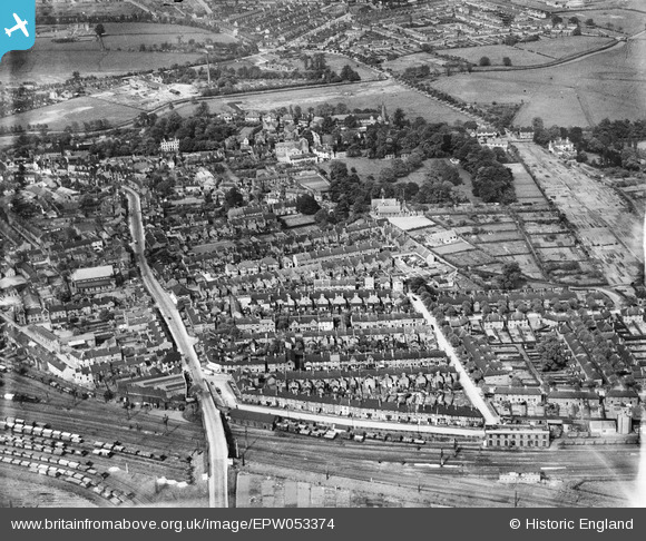
1940.
LimboBrit
A few posts under my belt
I used to go playing over Kingston Hill when I was staying with my gran on Tixall Rd.
Me too. I would be staying with my gran though not yours.