-
Welcome to Stafford Forum. Please or sign-up and start posting!
You are using an out of date browser. It may not display this or other websites correctly.
You should upgrade or use an alternative browser.
You should upgrade or use an alternative browser.
Salt Production In Stafford.
- Thread starter The Hawk
- Start date
Gramaisc
Forum O. G.
There was a railway siding off into the Salt Works from the eastern end of the Stafford Common station* platforms, on Aston Terrace. If you dig your way though the undergrowth to the fence of Webb's plant hire yard, you should be able to see the remaining rails in their concrete yard. Last time I looked, the remains of this signal were still there, too.

You can (just) see a rail in that picture, too - just this side of the nearest yellow implement.
* The platforms are still there, but very overgrown now, although the edges are easy enough to see, as you proceed along the Isabel Trail.
You can (just) see a rail in that picture, too - just this side of the nearest yellow implement.
* The platforms are still there, but very overgrown now, although the edges are easy enough to see, as you proceed along the Isabel Trail.
Gramaisc
Forum O. G.
The salt is largely underground, as it is in Cheshire. There are areas, one notable one on the lower of the Astonfields balancing Lakes, where salt marsh plants do grow, but this is largely due to residual pollution from the adjacent works.So, if Staffords on some kind of Salt Marsh, how do all these plants grow? And did the village 'Salt' get its name because of salt?
The extraction method was 'hydraulic', driving water down to dissolve the salt, then boiling off the water from the brine that came back up, to extract the salt content.
There was, in the late 70s, a plan to open a coal mine at Salt, but one of the potential problems that caused it to never happen was the chlorine contamination of the coal there.
DoggedWalker
Well-Known Forumite
The mention of the Common station… do remnants of this remain on the common? I’m sure I’ve walked past this and wondered about it. Interesting.
Gramaisc
Forum O. G.
The platforms remain, overgrown, on the east side of Common Road bridge. The station "buildings" were actually up at the bridge height, with steps down onto the platforms.The mention of the Common station… do remnants of this remain on the common? I’m sure I’ve walked past this and wondered about it. Interesting.
Google Maps
Find local businesses, view maps and get driving directions in Google Maps.
The platform edges can still be seen from the Isabel Trail.

Last edited:
littleme
250,000th poster!
A coal mine in salt? Not a salt mine? Was the seam of the coal mine at salt in the direction of Stoke/ Hem Heath?The salt is largely underground, as it is in Cheshire. There are areas, one notable one on the lower of the Astonfields balancing Lakes, where salt marsh plants do grow, but this is largely due to residual pollution from the adjacent works.
The extraction method was 'hydraulic', driving water down to dissolve the salt, then boiling off the water from the brine that came back up, to extract the salt content.
There was, in the late 70s, a plan to open a coal mine at Salt, but one of the potential problems that caused it to never happen was the chlorine contamination of the coal there.
Gramaisc
Forum O. G.
It was a coal mine, to be called the Park Mine, possibly to make it sound a bit nicer.A coal mine in salt? Not a salt mine? Was the seam of the coal mine at salt in the direction of Stoke/ Hem Heath?
It was going to be around here-
Google Maps
Find local businesses, view maps and get driving directions in Google Maps.
I've no idea about the relative geology of the seams.
Gramaisc
Forum O. G.
The obvious rectangle, to the north of the southern dam, was an area of "salt marsh plants" that was deemed to be left untouched by the large scale works that went on in 1990, to double the storm-water storage of the area, by building the upper dam to create a second lake. This was all done by about four blokes and their machinery over a period of a few weeks. No material was removed from or brought into the site, it was just moved around to open up the southern lake and create the northern one and its upstream dam.So, if Staffords on some kind of Salt Marsh, how do all these plants grow?
There are areas, one notable one on the lower of the Astonfields balancing Lakes, where salt marsh plants do grow, but this is largely due to residual pollution from the adjacent works.
Google Maps
Find local businesses, view maps and get driving directions in Google Maps.
There is also, in the area between Peter James Court and the Shell garage, another 'amphitheatre' that has some capacity for water storage.
And, down stream, we have the transient appearances of Lake Sandon, too.
Withnail
Well-Known Forumite
One 'fact' i have about the salt works, that i genuinely don't know the truth in, is that when it was first established, Welsh coal miners were courted to move to Stafford to abandon the mines and work above ground in the salt works.
Finding the work here worse than the actual pits... , they abandoned ship and went back home to the comfort of the coal mines.
I have never even tried to find out whether this is true, for i am a strong believer in not letting the truth get in the way of a good story.
Finding the work here worse than the actual pits... , they abandoned ship and went back home to the comfort of the coal mines.
I have never even tried to find out whether this is true, for i am a strong believer in not letting the truth get in the way of a good story.
Mudgie
Well-Known Forumite
I'm not certain but remember it planned for near the junction of Within Lane and the B5066 Sandon Road rather than in Salt.There was, in the late 70s, a plan to open a coal mine at Salt, but one of the potential problems that caused it to never happen was the chlorine contamination of the coal there.
Gramaisc
Forum O. G.
That's the same one.Wasn't there a coal mine proposed for Hopton some decades back, or is that the same one ? I read that the idea was abandoned due to poor quality coal, or that some attempt might be made to come at it from Cannock, also abandoned presumably.
It was going to be between Within Lane and Salt Banks.
The internet is almost silent on it.It was going to be around here-

Google Maps
Find local businesses, view maps and get driving directions in Google Maps.www.google.co.uk
BobClay
Well-Known Forumite
WOW Salt has expanded a bit !!! We used to play in the derelict Salt Railway Station as kids after walking up through deep railway cuttings parallel to the Sandon Road, just past the Hopton turn off (where there was a railway bridge, now long gone.) You can still see the outlines of the cuttings on Google Earth.
Gramaisc
Forum O. G.
The cuttings were filled in and the embankments removed - the Hopton Lane bridge stood oddly alone for a long time, before it was demolished.WOW Salt has expanded a bit !!! We used to play in the derelict Salt Railway Station as kids after walking up through deep railway cuttings parallel to the Sandon Road, just past the Hopton turn off (where there was a railway bridge, now long gone.) You can still see the outlines of the cuttings on Google Earth.
I think the bridge on Within Lane is actually still there, but filled in to the point of hardly being noticeable as a 'bridge' now - the parapets are still there, anyway.
Google Maps
Find local businesses, view maps and get driving directions in Google Maps.
And the railway bridge over the Trent, after Salt, was also demolished.
I think the Bridge on the A518, which went over the railway before Weston, was also removed in the 90s.
Gramaisc
Forum O. G.
Especially when you consider what our marvellous water companies are regularly pumping into the sea.It always amuses me when some companies sell products with "sea salt" listed as if it is some exotic ingredient. The salt mined from the ground is sea salt too, from when those areas of the land were under the sea.
BobClay
Well-Known Forumite
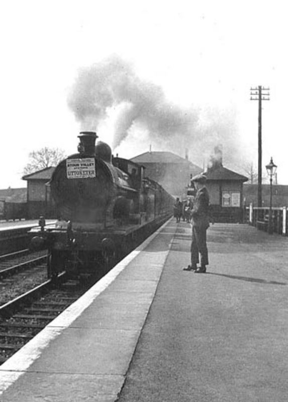
It is possible to follow the old railway beyond Salt on Google Earth, most of the way toward Uttoxeter.. I remember a few years back going out as far as Loxley Tunnel on the other side of Chartley Castle. I took a few pix which I put on another thread somewhere. Apologise for the repetition, but I like this pix of the tunnel in its hay day, and my pix taken in 2014.

Mudgie
Well-Known Forumite
And the cutting southwards, and possibly northwards, was filled in with being the Borough Council's refuse tip about forty years agoI think the bridge on Within Lane is actually still there, but filled in to the point of hardly being noticeable as a 'bridge' now - the parapets are still there, anyway.
Mudgie
Well-Known Forumite
I hadn't realised it was single track, but not surprising for a minor line built later and closed earlier than most.It is possible to follow the old railway beyond Salt on Google Earth, most of the way toward Uttoxeter.. I remember a few years back going out as far as Loxley Tunnel on the other side of Chartley Castle. I took a few pix which I put on another thread somewhere. Apologise for the repetition, but I like this pix of the tunnel in its hay day, and my pix taken in 2014.
View attachment 13026